 What Ever Happened To Linden Ave? Deehan Ave? Wilde Lane?....
surprise quiz - match the original street name (column A)with the one you remember from the sixties (column B):
column A
Grant
Wilde Lane
Vernon
Linden Av
Deehan Av
and, so you don't feel like a total loser:
E 44 St
column B
Linden Blvd
Troy
Tilden
Linden Blvd (2)
Snyder
Church Av
See the bottom of this blog for answers. No cheating! No help from your parents!
Before we begin, did you read the posting in the column to the right? Did you read the blog that appears below this one? Good!
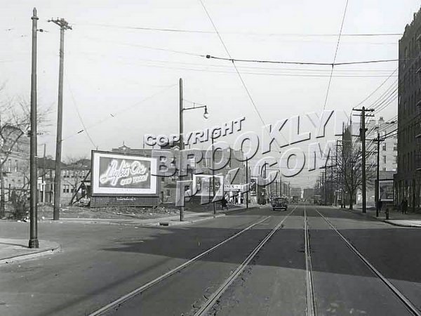
The picture, courtesy BrooklynPix.com, at the upper right of this blog is
what is now Linden Blvd looking west at Utica Avenue toward
E49th St taken in 1924. If you look carefully, that tall building on the left,
about two blocks away is PS 135. The tracks in the foreground carry the Utica
Avenue trolley. Check out the cobblestones. Smooth roadway had not yet entered
the lexicon of road builders.
There were some major thoroughfares that took us out of the
neighborhood, but none could offer us the vastopportunities afforded by Linden Blvd. Whereas Church Avenue and Utica Avenues provided easy transport to all three subway lines and various connecting surface lines, their ultimate destinations were all within the confines of the five boroughs. Even Kings Highway - my, what a regal name - while it meanders through so many Brooklyn neighborhoods and grows to an eight-lane giant by the time it reaches East Flatbush (yeah, the Department of Traffic considers the curb lane as a lane, even though it's primary purpose is for parking) it meets an ignoble, and some may say, untimely end at Howard Avenue in East New York. Even Utica Avenue at its southern terminus contributes to Flatbush Avenue's march toward Floyd Bennett Field and the Marine Park(way) Bridge.
In all fairness, even Linden Blvd has a humble beginning, with
its start at Flatbush Avenue between Caton and Church Avenues as a one way
eastbound street. How many of you have ever visited the Flatbush branch of the
Brooklyn Public Library on Linden Blvd just east of Flatbush Avenue?
If you were fortunate to grow up in a family with a car, NY
Route 27 - Linden Blvd - was the way to get out to the country. Route 27 starts
at the Gowanus Expressway, shares the right of way with the Prospect Expressway
and then heads east on Caton Av until Bedford Av where Caton ends and makes a
slight left turn to join Linden Blvd. At this point Linden Blvd is flanked
primarily by six-story apartment houses, interspersed with the occasional
two-family house. While not high-end, the houses do exude a degree of
upper-middle-class class - many had doormen, at least in the nineteen thirties
and forties; by 1960 they had long-since peaked. By the
time the traveler reaches New York Avenue there are more and more four-floor
'walk-ups.' No elevators! And more two-family homes.
I've been unable to confirm this, but while I was growing up on
Linden Blvd rumor had it that the white line down the center of Linden Blvd
separated more than just the on-coming traffic. It allegedly also served as the
boundary between the six-seven and the seven-one police precincts, now part of
Brooklyn South. The word was, 'Don't ever get hit by a car while standing on
the white line; neither precinct would respond. Drag yourself to either side.'
Further east, probably around New York Av, the white line (yes,
'white'!) also served as the boundary between Erasmus Hall and Wingate High
Schools, once the latter opened in the late fifties.
There is nothing of any architectural significance until Albany
Av and St. Catherine’s RC Church and school. If you lived in the neighborhood
and you were Catholic, you went to St. Catherine's. As a result, the local
elementary school, PS 235, on Lenox Rd at East 39th St was predominantly
Jewish.
Seven blocks east was East Flatbush Jewish Community Center, on
the corner of Schenectady Av. Well, actually, not on the corner. The plan was
to build a sanctuary on the vacant lot on the corner and convert the original
building into a community center - a dream that never materialized. The
building is now a church. Diagonally opposite is PS 135, an imposing five-story
building that was old sixty years ago. And a block further, across the
street was a brand-new health care facility. (Help me out folks: I think it was
a nursing home. Interboro?)
I bought my first tank of gas at the Texaco gas station on Utica
and Linden. (27.9 cents for regular, leaded gas and they checked my oil!). 1959
was a very good year. I learned every bump and pot hole on Linden Blvd.
The Rugby library's first home was east of Utica, in a row of
stores on the north side of Linden Blvd, before it moved to a new, larger building on Utica and Tilden Av.
Linden goes through another change east of Kings Highway. The
intersection of Kings Highway, Remsen Av and Linden Blvd has to be the most
pedestrian-unfriendly intersection in the City. (Actually, in 2003 there were
92 accidents at the intersection, ranking it the fourteenth most dangerous
intersection in the City. In the early fifties there was some talk and plans were proposed to make one of the roadways under ground. No doubt the plans were left on the center island of the intersection and no one was brave enough to retrieve them. Pennsylvania Av at Linden Blvd was more dangerous -
103 accidents that year.) Anyway, on its steady march to the 'country,' Linden
Blvd now becomes an eight-lane monster.
Linden Blvd had an interesting traffic control arrangement as it
sliced through East Flatbush. Not every intersection had a traffic light. Small
signs well-hidden on lamp posts at each corner advised drivers to stop at the
intersection if the light ahead of them was red. In most cases the lights were
at three-block intervals. For example, Albany Av had a light and the next
eastbound light was at Troy Av. The next light was at Schenectady Av, three
blocks to the east and then another three blocks at Utica Av which sported an
overhead signal. This traffic control concept might have been successful had it
been a universal policy throughout the City or if Linden Blvd were in the
middle of a desert with no foliage growing in front of the traffic lights or
the small signs.
Traffic lights were black four-sided box-shaped lights which
were effective only at intersections that were true right angles. They were
mounted on stantions about ten feet high at the curb on the corner. Usually two
signals controlled an intersection, mounted diagonally across the street from
each other. And, they were absolute. Either the light was red or it was green,
and the second the light turned red for one direction, it turned green for the
waiting traffic. In a nod to fairness, the Department of Traffic experimented
with the equivalent of an amber signal. Just before the signal would turn red,
both green and red signals would be lit. In New York, that was typically viewed
as a signal to speed up.
Now, for the poor hapless driver waiting, say at East 43rd St.,
to cross Linden Blvd. He was instructed via a small sign where normally there
would be a stop sign to look in both directions to see if the light was red for
traffic on Linden so he could cross. Even if it were red, there was a
fifty-fifty chance that some Linden Blvd driver would not stop at East 43rd St,
but continue on to the next traffic light. Obviously, to make this work, all
the lights had to change at the same time. If our hero made it across Linden
Blvd he was greeted at Lenox Rd with a yellow stop sign (with reflective bead
letters) and another stop sign at Clarkson. Standardized red stop signs were
still years away as were three-light traffic signals and progressive signals to
keep traffic moving at a steady pace and yellow lines down the center of the
street. Someone in the City government woke up and by the end of the fifties,
Linden Blvd had joined the ranks of other streets with a more conventional
traffic control system.
Although
it loses its identity somewhere at the Queens border and becomes North Conduit Rd,
it still maintains its Route 27 title as it continues east on The Sunrise
Highway which was built in the 1920's to alleviate the congestion on Montauk
Highway. It will go through several such changes until 122 miles from its
western beginning, it ends at a non-descript traffic circle at Montauk Point.
OK. A word about Vernon Av - not to be confused with the Verson in Long Island City. As anyone who spent at least one semester in Tilden High School, the street and eventually the school was named after Samuel J. Tilden, an attorney and New York governor who battled Boss Tweed's Tammany Ring. In the most contested presidential election of the nineteenth century Tilden came up one electoral college vote short to Rutherford B. Hayes despite gaining the popular vote and there went Brooklyn's claim to having a president of the United States. Hey, it couldda been worse. You coulda graduated from Vernon High School.
Our next session, we're going to discuss where we bought 'stuff.' You know,
like food, clothing. Like I said, 'stuff.'
Quiz Answers:
Grant - Snyder Av; Wilde Lane (later became Church Lane)- Church Av; Vernon - Tilden Av;
Linden Av - Linden Blvd; Deeham Av - Linden Blvd; E44 St - Troy Av.